A few years ago, satellite images were seen as a decisive technological advance that could reveal the truth about war crimes. Satellite images provided essential confirmation of atrocities in Srebrenica and Sudan. But those who violate human rights have learned from this, and are now devising counter-strategies.
When Bosnian Serb forces massacred some 8,000 Muslims in the enclave of Srebrenica in July 1995, photos gathered by US secret service satellites gave the lie to Bosnian Serb nationalist denials. The images of prisoners standing for execution and freshly dug ground at the sites of mass graves made it impossible to deny evidence of the biggest massacre in Europe since the Second World War. These satellite photos were the first to be used as evidence by an international court, the International Criminal Tribunal for the former Yugoslavia (ICTY), to prosecute Bosnian Serb generals Kristic and Mladic.
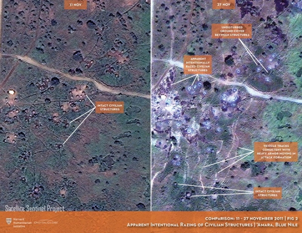
Since this precedent was set, the United Nations, Human Rights Watch, Amnesty International, UNOSAT, The Signal Program of Harvard Humanitarian Initiative, AAAS and other organizations have developed satellite imagery to denounce war crimes such as Boko Haram’s destruction of villages in northern Nigeria or others in Ethiopia, Eritrea and Darfur (Sudan). If Sudanese President Omar Al Bashir, wanted by the International Criminal Court (ICC) for genocide, is one day brought to trial, the Office of the Prosecutor will no doubt use satellite photos to show the destruction wrought by his soldiers and their Janjaweed henchmen. At the International Court of Justice, Georgia and Russia are accusing each other of war crimes and using satellite photos to back their allegations.
So is satellite technology the fatal weapon to catch perpetrators of mass crimes? The answer is not simple, because there are many factors that limit the efficiency of satellite surveillance: the presence of clouds or forests where the crimes are taking place; the high cost of images from commercial satellites, even if NGOs and human rights groups get discounts; the need to have human resources on the ground to flag the territory for satellite surveillance and enrich the information gathered; the lack of analysts capable of “reading” and interpreting the images; and the absence of protocols and standardized methodologies accepted by courts. Indeed, judges need expert witnesses to explain the satellite photos, because they are not explicit enough in themselves. At the moment, international jurisdictions consider that satellite images alone do not constitute sufficient evidence of crimes committed, even if they are a key element to corroborate the accusations.
State counter-strategies
States, especially those with strong technological capacities, have understood perfectly the danger posed by these images taken from space, which respect no borders and could implicate fighters suspected of war crimes. They have therefore developed counter-strategies, using the same satellite technology and drones to manipulate information. This is explained by Josh Lyons, a leading expert on image analysis who has been working for Human Rights Watch (HRW) since 2012. He looked, for example, into the destruction of a school in Idlib, Syria, in October 2016 that caused the death of 22 children and six teachers. The Russian Television channel used images from drones to claim that Russia had not attacked the school as alleged by UN peacekeepers and HRW, since there was no damage to the school roof and no bomb crater.
After patient analysis corroborated by information from people on the ground, Josh Lyons demonstrated that the Russian air force – which is the only one flying over this territory – had dropped a bomb with a parachute which exploded three meters from the ground, that is, without damaging the school roof or causing a crater. It is meticulous work, and sometimes frustrating. “It took me a week of work,” says Josh Lyons,” and in the meantime media attention had shifted elsewhere.”
Satellite picture of the school at Idlib where 22 children and 6 teachers were killed
on October 26, 2016 (Russian Ministry of Defense, shown on RT)
In the war of information that all the protagonists are waging, the rules of the game are changing. For several years, the big human rights organizations had got a technological advantage through satellite images. Governments that have the capacity – and not only Russia – are now using the technology to get their version of events into the public space and sow uncertainty. We have moved from having no images to having too many images. In the era of fake news and other “alternative realities”, this war over what happened has now been extended to the photos from space.


